One day this past week was spent at the Allen County Public Library attempting to determine the validity of the statement made in an article by Carrie Bray in 1949 that her great-grandfather (my 3rd great-grandfather) John Bray had arrived in Indiana on March 5, 1816.
An affidavit by Daniel Bray in the Revolutionary War pension file of his father John Bray, stated that “Some time in the early part of the year 1816, he went to the land office of Cincinnati to enter the North East quarter of Section No 25, town No 2, range 3 West. That owing to some mistake in the land office he could not effect an entry and he was obliged to return home and that his father John Bray, then went to the office and entered the said quarter...”
So the “problem” was: When was the land actually purchased and why did Daniel state that it was in Range 3?
The book “Indiana Land Entries Volume I” by Margaret R. Waters, published in 1948, contains the records for Indiana that are from the Cincinnati Land Office. It covers the area known as the “wedge” in the southeast corner of the state.

The map above shows the status of the Indiana Territory in 1810 with the four counties in existence at the time: of Knox (Kn), Harrison (Har), Clark (Clk), and Dearborn (Dea). The “wedge” mentioned in the Waters book was the area known as Dearborn county in 1810 as well as neighboring portions of Clark County.

By 1814 there were a few more counties in the Indiana Territory. Franklin and Wayne counties were created in 1811 while Switzerland was created in 1814 from that Dearborn “wedge” area as well as from portions of other counties. The two maps above are from the Genealogy Inc. website.
In the introduction of her book, Margaret R. Waters states that the records were copied solely for genealogical purposes to enable a searcher to learn if an ancestor located in Indiana and if so, where and when. To save time and space the acreage and final certificate numbers were omitted. A minimum amount of information is given (name, property description, date of entry) but enough to determine if the person of interest entered land in what would become the state of Indiana.

At the top of page 79 was the entry for John Bray showing that he entered the “NE 1/4 of S25 on 3-5-1816”. The line just below John, includes the name of Edward Ray who may be the same person who married Jane Bray, daughter of John. The previous page (78) showed that the land was in Switzerland County in T2N, R4W of the 1st PM (Township 2 North, Range 4 West of the 1st Principal Meridian).

The map above (from the Waters book) shows the “wedge” area of land from the Cincinnati Land Office included in the book “Indiana Land Entries Volume I”.

This enlarged portion of the previous map shows the townships that comprise Switzerland County. The dotted lines show the boundaries of Switzerland and Ohio Counties. (Ohio County was created in 1844 from Dearborn.) The land that John Bray purchased was in T2N R4W, which is in that tiny red triangle bordering Range 3 West.

Portion of a Switzerland County Map from the My Indiana Home website showing the location of Braytown in Craig Township.
Luckily for me, the Allen County Public Library has a series of microfilms called “Ohio Land Records” which includes the records of the Cincinnati Land Office. Film OLR-110 contained “Cincinnati Land Office Entries, 1814-1829” and it was even indexed by page number. Most of the page numbers were missing or illegible but it didn't take long to find his entry since I had the date he entered the land.

Cropped portion of the page showing the entry for John Bray (last entry on the image). The date at the top shows the transaction was made on March 5th 1816. The text in the column on the right states “John Bray of Franklin County applied to enter the North East quarter of Section 25 Town 2 Range 4 West - Containing 159 44/100 acres and produces the Receiver's Receipt No 30668 dated this day for $79 72/100 amt [?] being the one fourth part of the purchase money of said quarter Section of Land.”
So it seems that the date of March 5, 1816 as given by Carrie Bray in her 1949 article correlates to the date of purchase of the land. It also confirms the statement made by Daniel Bray in his affidavit that he went to the land office in Cincinnati “some time in the early part of the year 1816”.
But there was a surprise in the land entry document - the statement that John Bray was “of Franklin County”.
In searching the web for information, I came across the site Cincinnati Land Office Records, which appears to be a part of the Ohio Memory project even though those records are not included in their list of collections. The site contains images of the original land patents issued to the purchasers. There are only a little over 300 documents currently online but it is going to be an awesome site when they get more documents published. Anyway, at the bottom of the second paragraph of “About this collection” it states
“In certain instances it has been impossible to determine the correct state of origin of the purchaser; generally this is due to the fact that both Indiana and Ohio have identically-named counties, such as Franklin County. In these cases, both Ohio and Indiana have been listed as the state of origin.”
So that might present a little problem. However, Franklin County, Indiana is so very close to Switzerland County while Franklin County, Ohio is further north and east, closer to the central part of Ohio. Since we don't know the whereabouts of John Bray between 1805 and 1816 (as mentioned in The Evidence at Hand) it is possible that he could have ventured further north, but I don't think so. Perhaps that is just wishful thinking on my part. If he was “of Franklin County, Indiana Territory” then that would be evidence that he was actually residing in the area and would definitely be eligible for membership in the Territorial Guard Society of Indiana.
We have the record of the land entry on March 5, 1816 and the statement by Daniel Bray that he, then his father John, went to the Cincinnati Land Office in the early part of 1816. Does that constitute enough evidence to be able to say that they were then residing in the Indiana Territory?
What other records exist during that time period that can be used to help substantiate the claim that John Bray resided in the Indiana Territory in 1816?


 I've been gifted a stack of olderBicycle Quarterlyissues (thanks, A!) and a few of them are redundant with the ones I already have. So, if anybody wants them, I have the following three to give away:
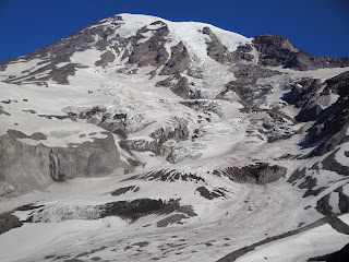


 This year the actual Solstice is on June 20 at 23:09, however its effects will be noticed for a much longer period of time and are in fact currently being observed. Since the 20th is a weekday you can actually make it to the Fremont Fair and the associated parties going on this weekend, get down, recover and STILL get out in the wilderness or wherever else you enjoy being for the actual day of Solstice. (Just assuming wilderness is your thing since this is a blog about climbing Mount Rainier.)
 Forget the Fendi Bicycle. It has been proposed that the first Italian designer bike was invented by Leonardo Da Vinci. The wooden construction above is a model "Da Vinci Bicycle", from an exhibition of the artist's inventions.
 A bicycle-like sketch was discovered in 1974 during the restoration of the Codex Atlanticus and attributed to Da Vinci. Conferences were held about this discovery; academic articles written... until 1997, when the sketch was proven to be a 20th century forgery.


 We took a tour of the lower level of the "big house". The owners still use the upper levels of the house. The house was built in 1936. It is listed on the National Register of Historic Places. The tour guide was dressed in costume and was very friendly and interesting. The TV series North and South with Patrick Swayze was filed here. The movies Queen with Halle Berry and The Notebook were filmed here also.
 The next thing you can visit is the row of slave cabins. They date back to 1790-1810 and are mostly in their original state. These were only some of the slave houses and would have been the workers that held more important positions. The houses were built with bricks that were made here and were evidence of the slaves' skills. Some of the bricks still have the handprints from their makers.
 Some of the crafts were on display. On top of that, a woman was there making some of the sweetgrass baskets.
 We took an open air coach ride to see the fields that are still in operation.
 Our favorite thing by far was learning about the Gullah culture. We first heard the word "Gullah" when we listened to the audiobook "The Mermaid Chair" together. We were honored to sit and listen to Carolyn "Jabulile" White, who grew up on the sea islands.